Geosite builds specialist software that uses geolocation to solve complex problems across infrastructure, services and public administration. Here you will find a modular, integrated solution ready to deliver measurable results and immediate ROI.
The complete solution for anyone seeking efficiency in telecom asset management. A full platform for accurate documentation, asset control and network expansion feasibility analysis.
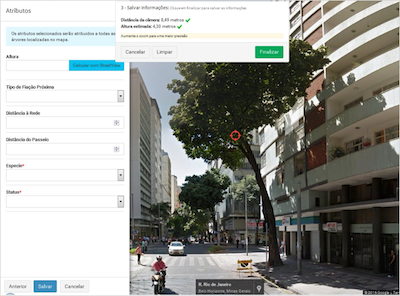
With Geosite Urban Forestry you centralise everything from the georeferenced inventory and plant health diagnosis to the operational maintenance schedule, delivering greater safety for public infrastructure and sustainable preservation of the local ecosystem.
Learn more
View every georeferenced tree. Record species and measurements, and monitor the health history of each individual tree in real time.
Use your phone camera to estimate height and diameter accurately. Record photographic evidence and plant health conditions straight from the field.
Set growth cycles and schedule preventive work. Organise the workflow to keep citizens safe and vegetation healthy.
A platform offering total visibility over field operations, with indoor tracking, work order dispatch and a complete history of jobs and routes.
Follow the location of teams and vehicles precisely, even indoors, thanks to exclusive indoor tracking.
Send jobs straight to operators' devices, with status updates and optimised routes at every stage of the service.
Store check-ins, check-outs, routes and every job for operational analysis and proof of contractual SLAs.
A Multipurpose Land Registry platform that unifies data from multiple government departments into a single integrated geospatial solution.
See how the city is growing and direct infrastructure and mobility investment strategically.
Give citizens and investors an intuitive map portal, opening up access to territorial information, zoning and online certificate issuing.
Centralise information from multiple departments in a single Oracle Cloud database, eliminating redundancy, registry errors and internal red tape.
A platform combining drone-based aerial mapping, prioritisation of Aedes aegypti breeding sites and work orders for health agents — from the flight to the final report.
Drones fly over risk areas and reveal breeding sites that manual inspection cannot reach, classified by type and severity.
Work orders with optimised routes reach the agents' app, and every visit is recorded with a photo and geolocation — even offline.
A heat map of critical areas, indicators per inspection cycle and automatic reports for municipal accountability.
Talk to a specialist.
Thank you for your interest. One of our specialists will be in touch shortly.