Geographic intelligence in the fight against arboviruses

A complete solution for arbovirus management: find Aedes aegypti breeding sites with aerial mapping, prioritise critical areas, direct health agents and prove every action taken against dengue, Zika and chikungunya.

What does Geosite Arbovirus do for your municipality?

From the health department to the agent in the field, everyone works from the same geographic base.

Health Departments

Manage inspection cycles, track epidemiological indicators and produce accountability reports with full traceability.

Municipal Governments

Coordinate control efforts with integrated data, optimise public resources and protect the population before the mosquito completes its cycle.

Health Surveillance

Prioritise critical areas with the heat map, classify breeding sites by severity and direct resources to the points of highest epidemiological risk.

Health Agents

Receive work orders with optimised routes in the app and record visits with a photo and geolocation — even in areas with no internet signal.

How the technology works at every stage

From aerial detection to treating the breeding site, every step is recorded, tracked and synchronised.

1

Aerial mapping with drones

Drones with high-resolution cameras fly over risk areas and capture images that reveal potential breeding sites.

2

Validation and classification

The images are processed on the Geosite platform, and every breeding site is validated and classified by type, severity and location.

3

Automatic work orders

The system generates smart work orders and optimised routes, sent straight to field agents.

4

Treatment by drone or agent

Drones apply larvicide in hard-to-reach places; agents work on site, recording everything in the app.

5

Synchronisation and dashboards

Data collected offline synchronises automatically and feeds the control and accountability dashboards.

The Geosite Arbovirus web platform with breeding site layers over the municipal map

Web platform: the whole territory under control.

A geographic management environment showing every breeding site found over the aerial image of the municipality, organised by inspection cycle.

Book a demo

Integrated layers and base maps

Manage breeding site layers, territorial divisions, density maps and previous cycles all in one place.

Automated prioritisation

The system orders the response by severity and location of the breeding site, with no manual analysis required.

Smart work orders

Generate work orders by area and priority, with optimised routes for health agents.

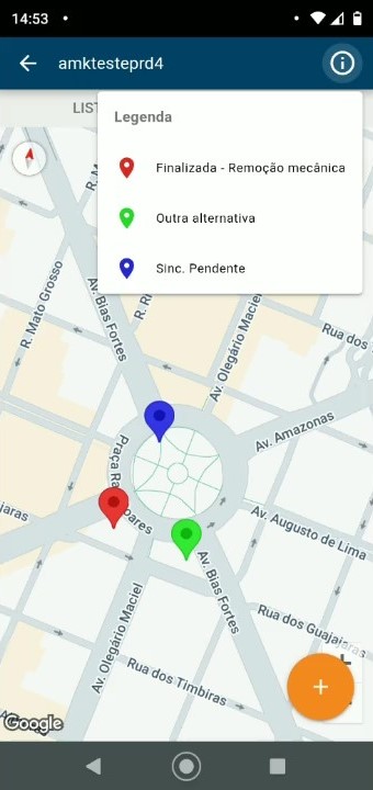
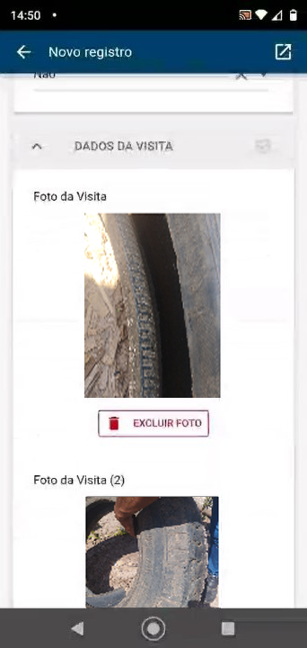
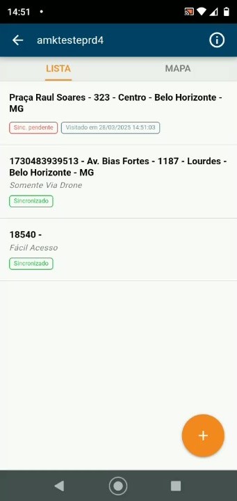
Agent app — visits on the map by status Agent app — recording photos and evidence from the visit Agent app — work order list with synchronisation

Integrated action in the palm of your hand.

Field agents receive optimised itineraries and record every visit in the app — even with no internet connection.

Offline with synchronisation

Work orders function without a signal; data synchronises automatically once the connection returns.

Photos and evidence

Upload photos of the breeding site and the treatment, with geolocation and a timestamp on every record.

Treatment record

Larvicide applied, mechanical removal or referral to a drone: every outcome is documented.

Results and operational gains

Less response time, more coverage and full transparency in reporting.

Reduced response time

Agents reach the breeding site on an optimised route before the mosquito completes its cycle.

Control and traceability

Every visit, photo and treatment recorded with geolocation and a timestamp.

Savings through prioritisation

Resources directed only to the zones of highest epidemiological risk.

Optimised routes and resources

Greater coverage in less time, with smart routes for drones and agents.

Transparency and accountability

Automatic reports for health departments, city councils and oversight bodies.

Precise breeding site location

Exact coordinates for every breeding site, with a photo and classification of the container type.

Success story

Voo pela Saúde: technology that protects lives

The partnership between GRS80 and Geosite brought together drones, geotechnology and smart management to transform the fight against arboviruses in municipalities across Brazil.

165
cities served
16,000
hectares mapped
7,000
breeding sites found and treated
2.5M
lives protected

Results from the Voo pela Saúde project — a GRS80 + Geosite Tecnologia partnership

Free e-book

Success Story: Voo pela Saúde

See in detail how the operation works in practice: the challenge, the partnership, the drone workflow and the results achieved in the municipalities served.

Download the e-book

Shall we fight arboviruses together?

Talk to a specialist.

R. Sen. Lima Guimarães, 479 - Estoril, Belo Horizonte - MG, Brazil